| Project: 1a and 1b) Survey
of Benin Iya - the world's second largest archaeological feature
Funders: 1a 1973-1977; 1b 1993-1995
-
1a) State Board of Education, Benin City,
Midwest State, Nigeria - salary
-
1a) Midwest State Military Governor's Office
- housing, transport & UK scholarship
-
1a) Federal Department of Antiquities, Lagos
- other project expenses
-
1b) British Academy - air flight, transport,
per
diems and other expenses
-
1b) Leventis Foundation - Okomu Forest Masterplan
surveys (Udo area),
accommodation for Bournemouth University
Conservation Science students
-
1b) IUCN - expenses of implementing conservation
measures.
Objectives:
-
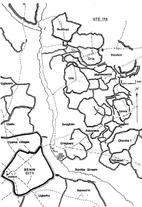
Project 1a aimed to map, date and interpret
this 16,000 km long linear earthwork cluster extending over 6,500 sq. km.
in the rainforest zone of southern Nigeria.
-
Project 1b aimed to identify the early
core zone of the earthworks, survey and date them.
Methodology:
-
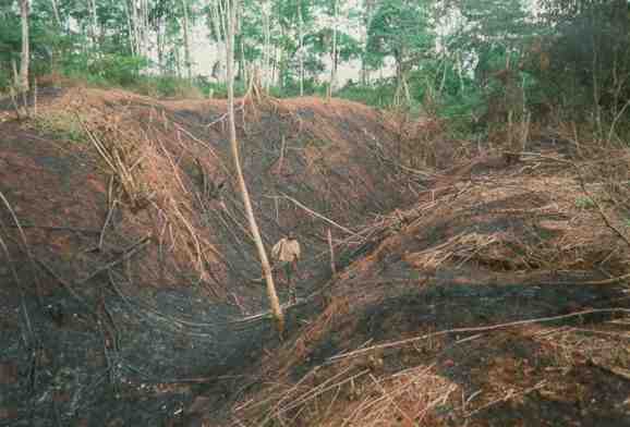
Surveys: Continuous transects were
made through forest, farm and fallow undergrowth using coordinates derived
from orienteering compass and pacing; then, using a plan variograph, these
relatively measured transects were scaled to fit known sites. In Project
1b, GPS measurements provided many more fixed points.
-
Sherds: Surface and sub-surface pottery
sherds were collected along a 160km traverse along the recently bulldozered
and dug 132kV transmission line crossing three distinct culture zones,
as well as from present day middens, known deserted sites and random sites:
form, decoration and fabric variables were put in a matrix for seriation
analyses using the Buckingham Double Shuffle - a form of lentifer analysis.
-
Linguistics: Basic word lists and their
relationship to one another were collected from linguists and subjected
to computer ramal analyses to produce trees for the very early history.
-
Other background data: collected on
the geology, soils, vegetation, customs, oral traditions and perceptions,
providing much new reference material.
Achievements:
-
About 1,000 km of earthworks were surveyed
and cross-profiles made in the first five months of the project - well
on schedule to map the whole complex in five years
-
Following a Military Coup and the cessation
of some funding, attention was focussed on the collection and analysis
of over 250 sherd collections and other background material.
-
Initial dating (project 1a) of the earthworks
was C13th-C15th A.D.; but later dating (project 1b) took the dating back
to the early C8th A.D. at Ekhor n'Iro east of Benin.
-
Sherd seriation and linguistic analyses showed
a strong north-south movement of Edo culture over the last six thousand
years.
-
Overall interpretations noted that a number
of early migratory ring fronts probably underlay the political processes
culminating in Benin's early kingdom formation: these included large petty
chiefdoms, the Ugha and Ishan kingdoms and the ihen ancient cult
patterns.
-
Sherds, oral history and old European maps
pointed to Udo being the phantom captial of the present royal dynasty of
Benin - a temporary superimposition of Yoruba culture onto Edo culture
between about 1450 and 1516 A.D. - but this is politically unacceptable
today and so denied by a variety of recent oral history ploys, which seem
to distort Benin's history as told by Prince Aiguabasimwin 80 years ago.
-
This was one of the first regional archaeological
studies in West Africa; and drew attention to the total cultural landscape,
rather than to eclectic little holes excavated piecemeal across Africa.
-
The surveys covered areas now destroyed by
Benin's urban expansion. This emphasizes the African Legacy's priority
of surveying Africa's visible archaeology while it is there.
Benin City, Udo and Ekhor earthworks were nominated as Nigeria's
first 2nd millenium UNESCO World Heritage Site.
|
 Udo
Town Wall Udo
Town Wall
 Yam
Barn Yam
Barn
 Water
store Water
store
|